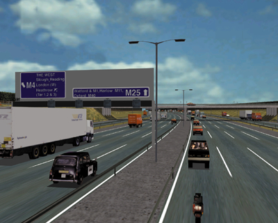
Aerobel provides both PC- & SGI-based systems for highway planning applications such as impact on environment, signing, safety assessments & training for major incidents.
These systems provide:
These systems provide:
- interactive control of eyepoint within high fidelity geospecific databases
- 1- to 3-channel; display giving a field of view of 50 -150 degrees
- 20/30Hz visual update rate at resolutions up to 1280x1024 pixels per channel
- on-screen controls and own heading & GPS position displayed
- correlated map display
- interactive movement of signs
- vehicles on routes
- control of time of day, sun angle & met visibility
- MMI controls (eg trackball/mouse or external joystick).
Aerobel’s products are based on commercial-off-the-shelf (COTS) hardware & software tools together with customised software to provide Customers with the following benefits:
- reduced initial procurement cost & whole-life cost
- maximum flexibility (eg changes to the GUI)
- protected software investment through the use of open format software
- significant growth potential (eg to handle more complex databases).
Aerobel's highway planning systems incorporate key features such as:
- anti-aliased, fully-phototextured out-the-window views
- use of optimised database features & line-of-sight culling for maximum realtime performance
- laser ranging & line-of-sight overlays
- rapid drive-through & teleporting facility
- God’e eye/helicopter views
- terrain-following, tether & stealth modes
- special effects (eg fires & smoke affected by wind)
- DIS-compliance.
Aerobel also provides:
- ruggedised systems
- analysis facilities
- stereo audio
- database converters (eg to import proprietary data formats into the COTS 3D modelling tools) for the generation/modification of geospecific databases
- database optimisation & modelling services
- desktop After-Action Review/stealth viewing systems
- desktop Reconfigurable Crewstations.
Press here and complete the form for the specification, literature & price.
Highway Planning
© Aerobel Defence Technology 2000